
Hawai‘i forecast severe weather through the weekend
Updates and reporting on the Kona storm impacting the state of Hawai‘i.

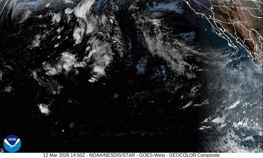
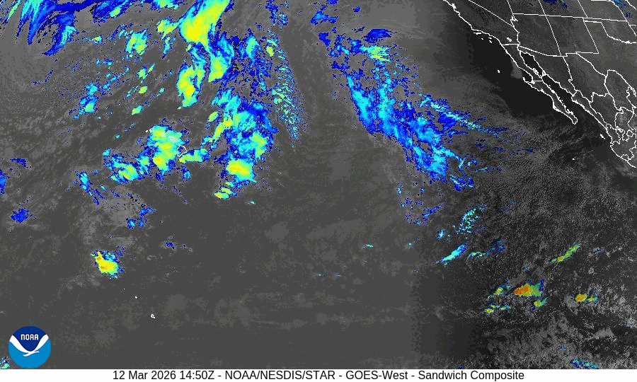
A kona storm is influencing local weather conditions across the Hawaiian Islands. Heavy rainfall, flash flooding, damaging winds, and strong thunderstorms are expected statewide, according to the Honolulu Forecast Office.
News Briefs & Updates: (Thursday, 12 March, 1:30 p.m. HST)
→ Flash flood warning issued for Oahu until 2:45 p.m., unless extended by the weather service.
→ Flood watch issued for all Hawaiian islands through Saturday, unless extended or alert upgrades.1
Several other National Weather Service watches, warnings, and advisories issued.
→ Rainfall average from yesterday reported to be about 2 inches for the state, according to preliminary NWS rain gauge data.
→ The weather event’s peak forecasted for Friday and Saturday.
→ Winter storm watch through Saturday for Big Island mountain summits.
→ On O’ahu Neighborhood Boards canceled scheduled meetings for Thursday, March 12.
→ Emergency shelters will open by 5 p.m. around O’ahu as a precautionary measure for flood evacuations.
The governor of Hawaii, Josh Green, issued a second emergency proclamation that activated the disaster relief fund.
Monday, 9 March, 9 p.m. HST
Hawaiʻi local and state agencies respond to possible impacts from Kona storm
Ahead of the incoming storm, Governor Josh Green issued an emergency proclamation.
“We have big storms coming. First in Kaui. It’ll be heavy rains, there should be some flooding, and we’re concerned about that, concerned enough to do emergency proclamations to get some extra resources out into the community,” Green said in a video message on social media.
The order allows state agencies to mobilize resources quickly and temporarily suspend certain regulations to speed up response and recovery efforts.2
Local and state emergency management agencies are circulating information on social media and urge residents and visitors to sign up for emergency alerts, monitor official social media pages, and tune in to local media reports.
Each of Hawaiʻi’s four counties issue local emergency alerts through several communication channels. The states Hawaiʻi Emergency Management Agency compiled links to these communication resources online:
Hawaiian Electric advised that severe weather can cause temporary power outages. The company provides updates regularly on social media. Downed lines and outages can be reported online.
In the event of a power outage, water utilities say to keep water use to a minimum.
The Hawai‘i State Department of Land and Natural Resources has closed several state parks on Oahu and Kaui. Additionally, the agency stopped issuing camping permits for all state parks until further notice.
Kauaʻi
Polihale State Park: Closed to both day and overnight use, as of Monday, March 9, 2026, at 3 p.m.
Kalalau Trail: Closed until further notice, as of Monday, March 9, 2026, at 3 p.m.
Kōkeʻe State Park: People who are camping overnight at Kōkeʻe State Park on Monday, March 9, 2026, may stay until Tuesday, March 10, at 11 a.m. Thereafter, camping will be suspended until further notice.
Oʻahu
Kāʻena Point, Mokulēʻia Section: Permitted vehicle access will be closed as of Tuesday, March 10, 2026, at 1 a.m.
The agency is working to evacuate campers and hikers in these areas.
“DLNR is asking for everyone’s cooperation with this announcement of area closures,” the department press release reads. “People are advised to avoid forested and coastal areas due to the dangers of rising streams, flash flooding, falling trees, storm surge, or high surf.”
Visitors and residents should expect the possibility of additional closures that may limit public services and spaces in the next few days as the storm develops. Many events have been cancelled around the islands.
Monday, 9 March, 4 p.m. HST
Powerful Kona storm expected to bring flooding, severe weather to Hawaiʻi this week
A powerful Kona storm is expected to move into Hawaiʻi this week, bringing the threat of heavy rain, flash flooding, strong winds, and thunderstorms across the islands through the weekend.
According to the Honolulu Forecast Office, the storm could affect the state from Tuesday through at least Saturday as a developing low-pressure system northwest of the islands pulls deep tropical moisture toward Hawaiʻi.
The first impacts could arrive as early as Tuesday on Kauaʻi and Oʻahu, where the risk of flash flooding is expected to increase as the storm approaches. The threat of heavy rain and flooding is expected to spread eastward later in the week, eventually affecting Maui County and the Big Island.
Weather conditions are expected to develop beginning Tuesday as the system strengthens and moves closer to the state.
Meteorologists say the storm will pull large amounts of moisture over the islands, creating conditions for repeated rounds of heavy rain. Some areas could see rain falling over the same locations for long periods, which increases the risk of flash flooding.
Flooding concerns could grow later in the week if heavy rain continues for several days. Saturated ground can make it easier for additional rain to run off quickly into streams, roads and low-lying areas.
Strong winds may also develop later in the week as the storm intensifies. Those winds could be strong enough in some areas to knock down trees or power lines.
Thunderstorms are also expected to become more likely by midweek. Some of those storms could become severe, bringing damaging wind gusts, and possibly hail.
The storm could also create hazardous conditions for boaters and air travel. Rough seas, thunderstorms, and strong winds are expected over coastal waters, while periods of heavy rain could reduce visibility for pilots.
Forecasters say it is still too early to determine exactly where the heaviest rain will fall, but confidence is growing that the islands will see several days of unsettled weather.
Flood Watch: Be Prepared: A Flood Watch is issued when conditions are favorable for a specific hazardous weather event to occur. A Flood Watch is issued when conditions are favorable for flooding. It does not mean flooding will occur, but it is possible.
Flood Advisory: Be Aware: A Flood Advisory is issued when a specific weather event that is forecast to occur may become a nuisance. A Flood Advisory is issued when flooding is not expected to be bad enough to issue a warning. However, it may cause significant inconvenience, and if caution is not exercised, it could lead to situations that may threaten life and/or property.
Flood Warning: Take Action! A Flood Warning is issued when the hazardous weather event is imminent or already happening. A Flood Warning is issued when flooding is imminent or occurring.
Flash Flood Warning: Take Action! A Flash Flood Warning is issued when a flash flood is imminent or occurring. If you are in a flood prone area move immediately to high ground. A flash flood is a sudden violent flood that can take from minutes to hours to develop. It is even possible to experience a flash flood in areas not immediately receiving rain.
Source: National Weather Service
In Hawaiʻi, an emergency proclamation is a formal declaration by the governor that activates the state’s emergency powers during a disaster or serious threat to public safety.