
Hawai‘i records driest wet season in 30 years, drought to persist into dry season. More record heat predicted for the planet
Central Pacific hurricane activity predicted to be low, be prepared anyways. Summer wildland fire risk forecasted for the islands. All that and more, coming up.

From Honolulu, this is the High Tide Report.
I’m Anthony Albidrez. A heartfelt memo about myself later.
For now, here are weather and climate briefs from across the islands:
Climate context: 2024 was the planet’s hottest year on record, expect another record breaking hot year over the next five years

Wet season rainfall varied across Hawaiʻi
The 2024–2025 wet season in Hawaiʻi, running from October through April, was the second driest in the last 30 years, according to the National Oceanic and Atmospheric Administration. Despite a forecast influenced by a weak La Niña that initially predicted above-average rainfall, especially for leeward areas, most parts of the state recorded below-average totals.
La Niña refers to cooler Pacific Ocean temperatures near the equator, which can influence Hawaiʻi’s rainfall.
Kauaʻi: Līhuʻe Airport saw just 12.04 inches, marking its second driest season in three decades.
Oʻahu: Totals ranged from 50% to 90% of average; Honolulu Airport had 9.31 inches.
Maui County: Kahului and Molokaʻi Airports experienced some of their driest seasons on record.
Big Island: Windward regions received 40% to 70% of normal rainfall, while Hilo recorded its third driest wet season.
As the islands enter the dry season, NOAA forecasts one mixed plate
Above-normal rainfall is slightly favored for Kauaʻi and Oʻahu.
While the Big Island faces below-normal precipitation.
Maui County and the Big Island already begin the season in moderate drought or worse, increasing the threat of wildfires and water stress.
Communities relying on catchment systems or surface water diversions and non-irrigated farms, are expected to be the most affected.
Drought likely to persist or worsen in some regions, some rainfall for others
Dry conditions have worsened across Maui County and the Big Island, while brief April rain brought temporary relief to O‘ahu and Kaua‘i. Drought remains widespread and is expected to persist through the dry season, according to the weather forecast office in Honolulu.
Current drought conditions
Extreme drought: Now affecting parts of the Hāmākua, Kaʻū, and South Kohala Districts on the Big Island.
Severe drought: Covers much of North and South Kohala, Hāmākua, and Kaʻū (Big Island), as well as West Maui, Maui’s central valley, and leeward Moloka‘i.
Moderate drought: Present across the rest of Maui County and the Big Island, and now includes lower leeward areas of Kaua‘i and O‘ahu.
Abnormally dry: Conditions continue in other leeward parts of O‘ahu and Kaua‘i.
Recent changes
Drought conditions worsened on the Big Island and central Lānaʻi.
Conditions improved in windward O‘ahu, leeward Kaua‘i, and Niʻihau, following early and late April rainfall events.
April storms brought near-to above-average rainfall to many areas. Typical dry leeward regions remained well below normal overall.
Streamflows remain low, limiting water production in West Maui and several Big Island watersheds.
Ranchers in upper Hāmākua, lower Kaʻū, Kaupō, and Upcountry Maui continue to report poor pasture conditions. Water hauling and supplemental feeding remain necessary.
Upcountry Maui is in Stage 1 Water Shortage in effect.
South Kohala (Big Island): Water Conservation Notice remains active.
Outlook (Dry Season through October)
Above-normal rainfall is slightly favored for Kaua‘i and O‘ahu.
Below-normal rainfall expected for the Big Island.
Equal chances of above- or below-normal rainfall in Maui County.
Most existing drought is likely to persist or intensify, except in windward areas of Kaua‘i and O‘ahu, which may benefit from seasonal trade-wind showers.
Wildfire risk rising on Hawai‘i’s drier slopes
Hawai‘i’s wildfire potential is expected to stay low through June, according to the National Interagency Fire Center. Conditions are expected to increase in fire potential by July and August, especially on the state’s leeward sides. These are the hot, dry areas shielded from trade winds, like West O‘ahu, South and West Maui, Leeward Moloka‘i, and Kona.
Federal fire officials forecast above-normal wildfire risk for those leeward areas later this summer. These zones dry out faster. With hotter-than-usual weather expected and less rain in the forecast for some islands, grasses and brush could ignite more easily.
This seasonal shift is tied to changes in global weather patterns. The El Niño–Southern Oscillation, a natural climate cycle that influences rainfall and temperatures, has entered a neutral phase. This means Hawai‘i could see less predictable weather and more heat through the dry season.
Even though parts of the islands saw some growth in grasses after recent rains, vegetation in dry areas remains patchy. In places where the groundcover is thin or stressed from drought, wildfires can start and spread more easily, especially when paired with gusty winds or low humidity.
So far, the state has avoided critical fire conditions this year. No Red Flag Warnings (alerts for dangerous fire weather) have been issued. The only notable fire activity was a controlled burn carried out by the military at Schofield Barracks on O‘ahu.
Quieter hurricane season for Central Pacific forecasted, but cautions remain
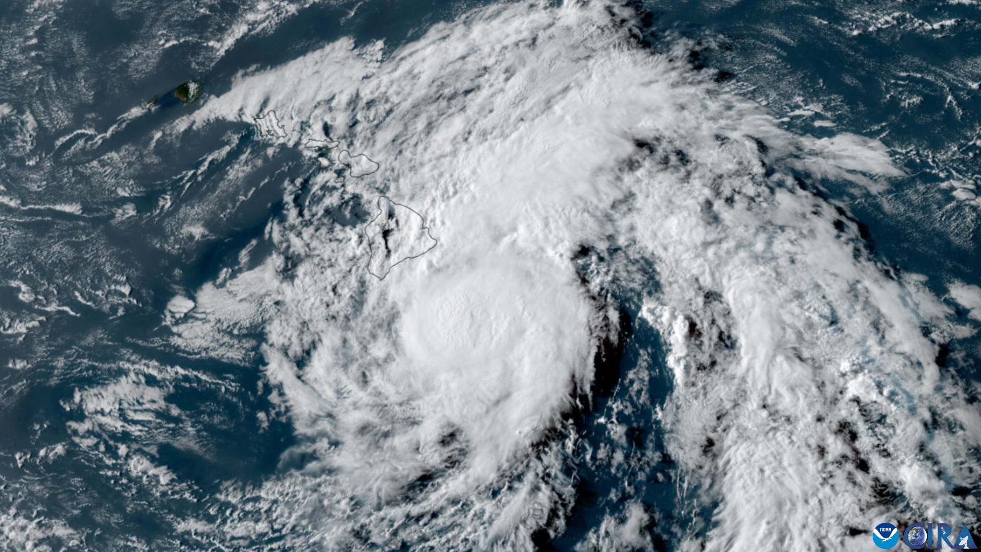
The 2025 Central Pacific hurricane season is expected to be less active than usual, according to the National Oceanic and Atmospheric Administration. The agency predicts a 30 percent chance of below-normal tropical cyclone activity between June and November, when the season officially runs.
On average, Hawai‘i sees four to five tropical cyclones per season. This year’s outlook suggests fewer storms, influenced by the likely development of La Niña, a climate pattern marked by cooler ocean temperatures in the central and eastern Pacific. La Niña tends to increase wind shear and atmospheric stability, both of which can suppress storm formation in the region.
Still, NOAA warns that seasonal forecasts don’t predict the exact number, timing, or track of individual storms. Even quiet seasons can bring damaging impacts.
Officials urge Hawai‘i residents to review emergency plans and stay informed. As NOAA puts it: it only takes one storm.
Most islanders, both lifelong and long-term, know their risk when it comes to tropical storms and the possibility of weather-related impacts to survival.
Plenty of information on that is out there, but let’s take a look at information provided by the Honolulu forecast office on how to know your risk.
Information provided by weather monitoring agencies are usually the same year after year and apply to coastal and inland communities.
High Tide will begin sharing the weeklong campaign topics even though the official Hawaii hurricane preparedness week is over:
The first topic titled “Know Your Risk: Water & Wind.”
Global temperatures likely to break records again by 2029, says United Nations climate agency
The World Meteorological Organization projects that global temperatures will remain at or near record levels over the next five years, intensifying climate-related risks worldwide.
Key findings from the WMO's latest report include:
80% likelihood that at least one year between 2025 and 2029 will surpass 2024 as the warmest year on record.
86% probability that at least one year in this period will exceed 1.5°C above pre-industrial levels (1850–1900).
70% chance that the five-year average temperature from 2025 to 2029 will surpass the 1.5°C threshold.
While the Paris Agreement targets long-term temperature averages, these projections underscore a trend of escalating global warming. The WMO warns that each incremental rise in temperature contributes to more severe heatwaves, intense rainfall, prolonged droughts, accelerated ice melt, ocean warming, and sea-level rise.
The Arctic is expected to experience warming more than three times the global average, with anticipated temperature increases of 2.4°C above the 1991–2020 baseline during the next five extended winters. Additionally, precipitation patterns are projected to shift, with wetter conditions in regions like the Sahel, northern Europe, Alaska, and northern Siberia, and drier conditions over the Amazon.
I’m Anthony Albidrez, reporting this High Tide Report. Subscribe, follow, and share.